
Machine Learning in Satellite Imagery
Valentina DISARLO
PhD, Postdoct at Universitaet Heidelberg
September 28th, 2023, 4 PM
Abstract
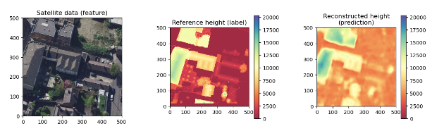
Satellite and aerial imagery are potent tools that can give extensive insights into our urban landscape. One specific area of interest is the detection of buildings, vegetation, and estimation of building heights. In this talk, we will commence with an introduction to the fundamentals of satellite image analysis and transition into an exploration of common machine learning techniques to detect vegetation and estimating building heights. We will compare the accuracy of different machine learning methods on a concrete dataset of images. A highlight of our discourse will be a dive into an innovative deep-learning method described in the paper "IM2ELEVATION: Building Height Estimation from Single-View Aerial Imagery" by Chao-Jung Liu, Vlad Krylov et al.
Supplementary Materials
Paper: https://www.mdpi.com/2072-4292/12/17/2719
Member discussion